Photo-essays, Welcome To My World
Photo-essays
My first magazine article, many years ago, was really a photo essay. Over the years, I have gotten away from that. I still take many photos but seldom publish them together. Until now, Welcome to my new section of photo-essays.
This area is well known for the quality of the alters and the Retablos. A Retablos is the structure behind the alter.
Photo-essays
What are Photo-essays?
Noun: A group of photographs, usually with supplementary text, that conveys a unified story and is published as a book or as a feature in a magazine or newspaper.
It is time for a change. I am going to create a series of photo essays. Some will be from photos I have taken in the past, others will be new. Some of these photographs will be on my Flickr site Another Photography task for this year, is to update that also.
Either way, welcome to my world of photography. Please join me in my travels. From the backyard to around the world. No passport required for you to experience it.
My recent Photo-essays
Traveling Nomad Photo-essays
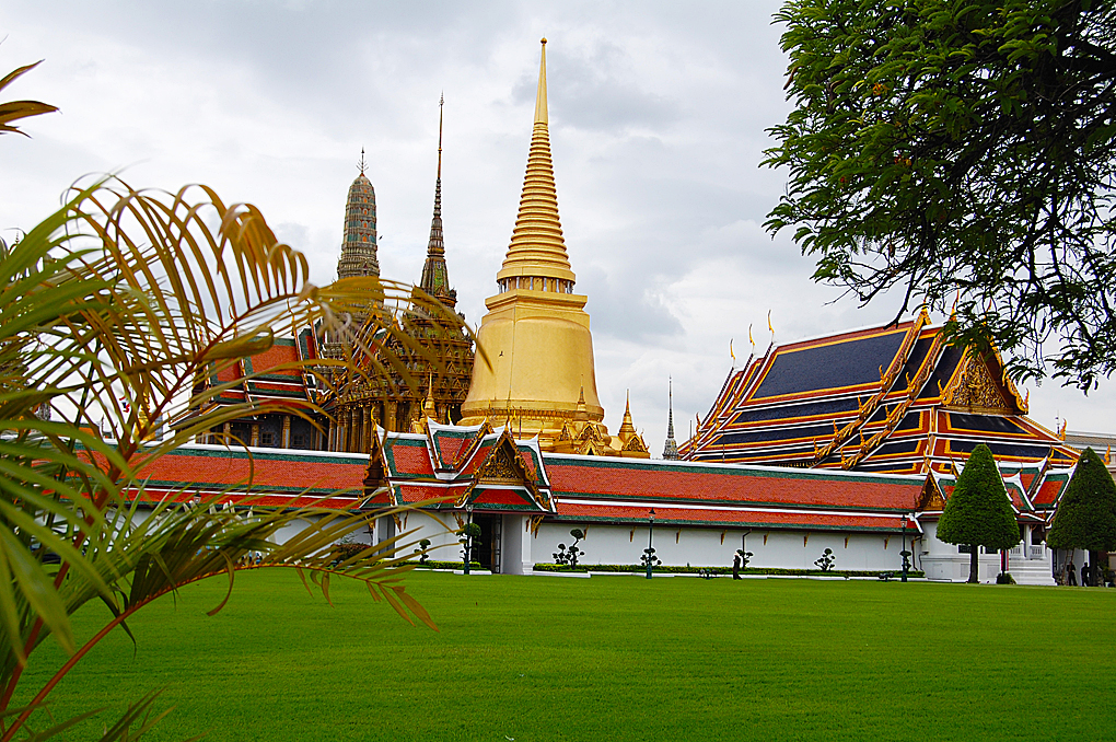
Grand Palace, Bangkok, Thailand
You have not experienced the heritage and culture of Thailand if you have not visited the Grand Palace. Construction started in 1782, when King Rama I moved his capital to Bangkok. Then known as the Kingdom of Siam, which you may know if you are a Rogers and Hammerstein fan, the name is familiar from the musical “King and I”. From that time to about 1925, this was the home to the King of Thailand. The Grand Palace covers 94.5 hectares (234 acres) and has over 100 buildings. Tourists are most familiar with the Temple of the Emerald Buddha, Wat Phra Si Rattana Satsadaram, which covers a small portion of the grounds. Temple of the Emerald Buddha One interesting point is that the Temple of the Emerald Buddha is not a temple and the Buddha is not emerald. Technically it is a chapel. A temple or in Thai a Wat contains residential structures for the monks, the Temple of the Emerald Buddha does not. The Buddha was carved from a single piece of jade, not emeralds. The history of the statue is very fascinating and mysterious, but some highlights are it was lost about 462 AD. Somewhere in time it was disguised and moved to Chaing Rai in 1432, in 1434 lighting struck the Chedi and rain damaged the items inside. While being examined by the monks, they saw that there was a chip in the statue and it revealed the jade. The color emerald and the gem share the same name and the statue was said to be emerald in color, which word of mouth just became an emerald. The official name of the temple translates to “the residence of the Holy Jewel Buddha” and it has been its home since 1784, the year the grounds were consecrated. This statue and the grounds it sits on are considered the most sacred for Thai Buddhists. Visitors should show respect and dress properly. A tourist in modern times enters what was the hermit gate, which was at the rear of the grounds. Sadly, some tourists get upset when they are told the entrance is about $12, but is free for Thai’s. My view is that they have been paying taxes to keep the place up for over 200 years, they deserve a break. As you enter the hermit gate to your left is a cover walkway, guarded by two 16 foot Yakshis, mythical giants. Many tourists in their rush to see everything frequently overlook this walkway. The walkway surrounds the temple grounds. On it are paintings. In 138 scenes, it represents The Ramayana, one of the two great epics of Hinduism, and it is fundamental to the cultural identity of Thailand and other Southeast Asian Countries. The story tells of Rama, which is the title that the Siam king took and is still in use today. While today this is the backside of the grounds and most tourists never venture here, this was the main entrance area of the grounds. You can see the second gate in the image between the two Chedi, the ceremonial gate is to the right and is kept closed. In the 19th century, the additional buildings were added, and they represented different styles of the region. The Phra Mondop, the library, was also built by Rama I. The doors are carved with mother-of-pearl in laid, the roof and supporting structure have carved flowers. There are some planters for water lilies around this area. The name Prasat Phra Thep Bidon (Royal Pantheon) means “The Shrine of the celestial Ancestors”. Originally built around 1855 by King Rama IV to house the Emerald Buddha, however, he died before it was finished, and the next king thought the area too small. The building has a different style when looked at the side and front. This was partly due to a fire in 1903, after repairs, life-size statues of the previous kings were added here. This building is open once a year April 6, to celebrate the founding of the Rama Dynasty. Around the grounds are small gardens, some in bonsai style with stone statues. A Ubosot is the main building of a Wat and features the most precious Buddhist image of the temple. In this case, the Emerald Buddha. This shows a little photographed area as it is the back of the building, behind the throne which the Buddha sits on. It is used by the king to change the dress of the statue. Three times a year, at the start of the summer season, winter season, and rainy season, the covering over the statue is changed. The king is the only one allowed to touch the statue. He removes the current covering, dust and cleans the statue, and dresses it in the new season outfit. It is thought to bring good luck and long life to the country. When not in use, the outfits are on display in the Museum of the Emerald Buddha Temple in the Grand Palace area. While photographs of the Emerald Buddha do exist, it is forbidden to photograph it. The Chedi are domes and like the Ubosot are home to artifacts. The Phra Sri Rattana Chedi is in Sri Lankan style was built in the early 1800s and is said to be the home to some of Buddhas ashes. The Grand Palace Once you leave the grounds of the temple, you enter the grounds of the Grand Palace proper. One of the largest buildings that you will see is the Phra Thinang Chakri Maha Prasat, The Throne Room. This was built in the late 1800’s using European style. However, towards the end of construction, it was decided that it would be only proper to have some traditional Thai style so the roof and spires were added in Thai style. This building was meant as a working center, today the ground floor houses museums showing military weapons from early times. It also includes gifts to the king that were of a military nature. There are many buildings in the Grand Palace, well over 100 with different styles. Some are of a more traditional style, such as shown in the roof structure of this building. The grounds are a major tourist attraction, but there are still official functions held here at times. One section of the grounds is closed that was built as the home for a secondary king, similar to a crowned Prince. It is now used as a guest quarters for visiting heads of state. The building shown here is next to the “Throne Room” and it is THE Throne Room. While the European-style building is the throne room for normal occasions, this building is the official one for the coronation and extraordinary functions. It was used during a celebration of the King’s 60th year as monarch. Kings and other Royalty from around the world gather here in a special tribute. While the king no longer lives in the grand palace, it still has the offices of the Royal household staff. Much of the responsibilities for some of these buildings still fall under their care. Plan to Stay a Full Day at the Grand Palace Many tourist companies will whisk you through the Grand Palace and the Temple of the Emerald Buddha as a part of a half-day tour. You can spend a half-day alone at the museum, some buildings open to the public get very few visitors but have outstanding history lessons. While in some buildings, you are not allowed to take photos, however, in most you are. In one visit, I was told that you are not allowed to take photographs in the formal throne room. Then the attendant took me outside the building and showed me an open window that I could photograph through. If you have only one day in Bangkok, this is where you need to spend it.
Macau World Heritage Site
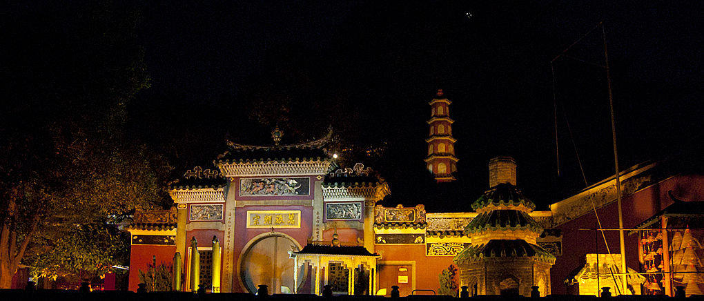
Macau World Heritage Site The Historical Center of Macau has over twenty-five sites and has been recognized by UNESCO as a World Heritage site. The sites shown here are all within walking distance. Macau (also spelled Macao) is one of those places that you think you may have heard of but not really sure about, but mention its sibling and everyone knows her. So it is with Macau and Hong Kong. Like Hong Kong, Macau is a Special Administrative Region of the People’s Republic of China. Also, like Hong Kong, it has a rich background that mixes two very different cultures. While Hong Kong was a British Colony until it was returned to the Chinese, Macau was a Portuguese colony. The Portuguese came to Macau in the mid 16th century, over 300 years before the British arrived in Hong Kong. The two cities are connected by a high-speed ferry that takes only an hour. UNESCO cites this “Macao, a lucrative port of strategic importance in the development of international trade in Chinese territory, became a Portuguese settlement in the mid-16th century and returned to Chinese sovereignty in 1999. The inscribed property presents a group of 22 principal buildings and public spaces that enable a clear understanding of the structure of the old trading port city. With its historic streets, residential, religious and public Portuguese and Chinese buildings, the Historic Centre of Macao provides a unique testimony to the meeting of aesthetic, cultural, religious, architectural and technological influences from East and West. It bears witness to the first and most enduring encounter between China and the West, based on the vibrancy of international trade” Macau is a thriving city complete with world-class facilities, including some of the largest casinos in the world. It has however been able to retain much of its cultural and historical sites. The A-Ma Temple An Macau World Heritage Site The A-Ma Temple is named for A-Ma the goddess of seafarers. It was in existence before the settlement of Macau and has places for Buddhist, Confucianism, Taoism, and various folk beliefs. The earliest remaining structure dates back to 1488. Tourists come from all over to visit the temple. Those of the religions represented by the temple can be found praying and offering incense. In some pavilions, the smoke is so thick that they have to use fans to keep the air breathable. If you look at the first two photographs, you will see a number of yellow pole-like objects. Those are incense burning. While there are literally thousands of pieces of incense burnt each day, you have to go to a designated smoking area for a cigarette. The grounds are no smoking. Macau World Heritage Site Business District While the city is built up with a number of skyscrapers, there are still many side streets that still maintain their history. This street here runs parallel to one of the busiest streets of the city and shopping district. The houses on this street trace back to the mid 1800s. Mandarin’s House Mardarin’s house was built before 1869, and was the family home of the Chinese Literary Figure Zheng Guanying. The house blends traditional Chinese designs and functions with western styling. At the entrance to the home is a shrine to the earth god, a common tradition of the times. The original builder and members of the family after him were local leaders. The house was designed so that visitors on government business had to leave their sedan chairs at the moon gate and walk along the courtyard to the receiving area. The house was designed in a courtyard fashion, with front and back halls between the two halls were the bedrooms that open onto a courtyard. The second floor of the house in the front hall was the main hall for formal occasions. There is another room behind the one shown. St Lawrence Church St Lawrence Church built by the Jesuits dates back to the mid-16th century and is one of the three oldest churches in Macau. The current design of the church dates back to 1846. The courtyard surrounding the church also dates back, with some features being part of the original development. There are however more recent additions such as the glass etchings. My guess is the image is fairly new, the hint is the Google plus one address that is also etched in. St. Augustine’s Square The St. Augustine’s Square is done in a traditional Portuguese manner and four significant sites around it. The Brown marker is a map and explanation of the historical district. Each site also has a smaller marker of the same color and material that gives information about that site. The street post behind it gives directions to other historical sites. Originally established by Spanish Augustinian priests, this church dates back to 1591. Dom Pedro V Theatre This 300 seat theater was the first western-style theater built in China. Built across from the St. Augustine’s church, it was established in 1860. While small by current standards the theater is still used for different events. Sir Robert Ho Tung Library Originally built in 1894, this building was bought by Sir Robert Ho Tung, a businessman from Hong Kong, in 1918. Upon his death in 1955 the building was given to the government to use as a library. St. Paul’s Ruins Build between the years 1602 and 1640 the Church of Mater Dei was destroyed by fire in 1835, along with St. Paul’s College which stood next to it. St. Paul college was the first western-style university to be open in the Far East. These two structures plus the mount fortress nearby were built by Jesuits. Moorish Barracks Built-in 1874 on the slope of Barra Hill, this building was constructed to accommodate an Indian regiment from Goa appointed to reinforce Macao’s police force. Goa is a state in western India with coastlines stretching along the Arabian Sea. Its long history as a Portuguese colony prior to 1961. Being closer to Macau, soldiers could be replaced easier. Mount Fortress The Mount fortress was built between 1617 and 1626 and was the cities main military protection Senado Square Macau World Heritage Site Senado Square has been considered the center of Macau community life since its early days. The buildings around the square are in the Portuguese tradition. The square continues to be a popular location and many events are still held here. Overall the people of Macau have done a remarkable job of maintaining the history of the city while still allowing growth and modernization. Walking around the old section of the city and you could easily be lost in hundreds of years of history. St Dominic’s Church Macau World Heritage Site Photo-Essay When I was working for AOL in the Philippines, I had a business visa that was good for 59 days. I had three choices nearing the time limit. I could go to immigration and pay to extend my stay, I could convert to a working visa which was a long expensive process, or I could leave for 3 days and start a new 59 days when I returned. The third option is what I did. Hong Kong, Thailand, and Macau were only a few hours away, so I would alternately visit them. The photos here are a bit old but still reflect Macau.
Carnival Cruise Line Revisited
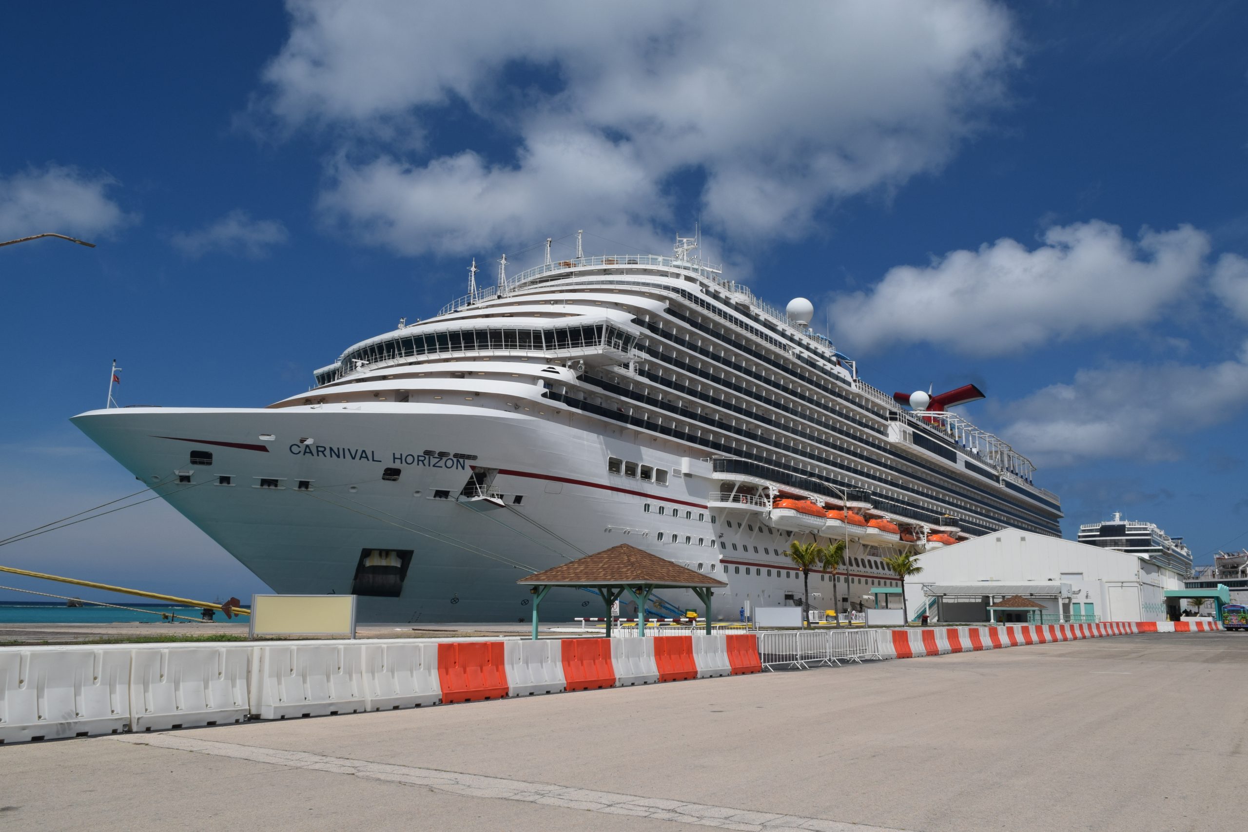
Revisiting Carnival Cruise My last Carnival cruise had been about 20 years ago. Back then the “Fun” of the fun ships seemed to be focused on drinking. Heavy often out-of-control drinking was the norm. I remember contests where couples would compete against each other for who could drink a yard of ale the fastest. Over the years, the Carnival cruise line has moved away from that image and does focus on families as well. I found an outstanding value for an 8-day cruise out of Miami, so I decided to take chance with Carnival Cruise Lines and booked it. At the time, using a third party, they were offering 0% financing. I bundled all the ship expenses together and started to pay over time. My frequent flyers account had ample points and using my Jet Blue account, I was able to get a flight where I only had to pay a few security fees. COVID requirements are always changing. Most of the people on the cruise were vaccinated, however, they did allow a few onboard with waivers. Vaccinated passengers and crew had to make up over 95% of those on board. Two weeks before my September 3 cruise, I received an email stating that all guests must obtain a negative COVID test within 3 days of sailing. Searching for a place to get the test done, I found that Miami International Airport had rapid testing available. However, when making a call to them, I found out they did not accept insurance and the cost of the test was over $160. I did find a place that was a ten-minute walk from where I was staying that also did the test and it was covered by insurance, so no out-of-pocket expense. A week before the cruise, Bonaire was replaced by Curacao. Sailing the Carnival Cruise Line’s Horizon A few weeks before the cruise, I completed the online check-in and downloaded the Carnival apps. A few days before the cruise, I had to return to the online check-in and update some health questions. I got a Lyft from my Miami Beach hostel and a short $12 ride later arrived at the Miami Cruise Terminal on time for my 10 am check-in. Leaving my checked luggage and a tip with a porter, I entered a short line to go inside the terminal building. Before going inside my ticket was checked, then another stop checked my vaccine card and COVID test. Mask had to be worn. Then it was to an airport-style security check and on to a long back and forth path to the check-in counter. There was no one in line and when I got to the front was directed to an available station. My passport was scanned, the vaccine card and COVID test information recorded, and a photo of me taken. I was given a boarding group card and in less than 5 minutes was on my way to a waiting area. It was not long before they started to board the suite guest and VIP members. General group boarding started around 11, and I was on board shortly thereafter. We were frequently reminded that masks were to be worn in all public areas except when actively eating. The staterooms were not available when we arrived, which is somewhat standard. So with my trusty backpack, it was off to the buffet for a leisurely lunch. I found a nice window seat where I could look out over Miami Beach. I put my phone into airplane mode and activated the Carnival app. Getting Started Carnival Cruise Style The app is a wonderful tool, that gives you all the information you need for the day. It has the schedule of events for the day as well as opening times of the restaurants and shops. You can book shore excursions, I did not, and check your onboard account. If you have an internet package, you can use the app to connect to the internet. I did purchase an unlimited basic package before the cruise at around $10 a day. Overall, I was satisfied with the speed and did not have any problems with it. Around 1 pm, announcements started advising guests they need to attend a safety briefing at their muster station before 4 pm. I made my way to my muster station which is shown on your sailing card. At the muster station, they scanned the card and in small groups of less than 10, they gave a short safety briefing and demonstration of the life vest. Very much like what you find on an airplane. In total, I was at the muster station for less than 10 minutes. This 8-day trip started with a couple of days at sea on the way to Aruba and Curaçao. The original schedule had Bonaire instead of Curaçao but that was changed a few weeks before sailing. After Curaçao, there was another sea day and then two stops in the Dominican Republic. It was difficult to judge how full the ship was. Based on the number of people in the dining rooms and at the shows, I would estimate the ship was about 50% full. Due to being in September and vaccine requirements, there were very few children on board. Food and More Food The saying of going on as a passenger and coming off as cargo is still alive and well. To be fair there are healthy choices. The Carnival Horizon uses early and late seating in their main dining rooms, with an option for flexible dining. If you are at one of the two seating, you are assigned to a table for the duration of the cruise. I had selected a late seating and was assigned to a table set for 10 but with only 3 other guests. The waiter said the assignments were for 6, but two never showed in the dining room. One of the table mates moved to another table shortly into the cruise. English was not her first language, and she meet up with another person who shared her language. Each night we had a selection of appetizers, soups, entrées, and desserts. About half the entrées stayed the same, while the other followed a nightly theme. One item that often got a chuckle out of me was a section labeled, Rare Finds – something you always wanted to try. These items were a bit exotic. I passed on the Escargot, and Braised Ox Tongue, which I have had before. I did enjoy the Alligator fritters. Dining Venues In addition to the dining rooms, there were a number of other dining venues. Some were complimentary and some had a surcharge. The complementary garden buffet was open for breakfast, lunch, and dinner. Overall, I was a little disappointed about the choice of food at the buffet. However, to be fair, it might have been due to not having a full sailing. There was a good selection of cakes at lunch but limited desserts at night and just cookies late at night. One thing I did find irritating was the beverage stations. A number of times, the one closest to the food was closed. There was a complimentary taco/burrito bar open for breakfast and lunch. Guy’s Burger Joint was complementary open for an extended lunch period. While Guy’s BBQ, a Mongolian restaurant, and an Italian restaurant were open for dinner as a surcharged venue. They were also opened on sea days for lunch without a surcharge. I did try those three at lunch and found the meals outstanding. There was also a deli station that was open from early lunch to late dinner. It seems very popular. A pizza place was open 24 hours, but it was more like cardboard for my taste. I heard others say the same and hear comments that the deli would be a better choice for 24 hours, which I agree with. Onboard Daily Activities We started the cruise with a few days at sea. I ended up eating too much because I really did not see many activities that pique my interest. I am not a gym rat, however, I generally try to spend some time in the gym while on a cruise and I also like to try some exercise classes as well. I was not impressed with the gym and ended up not spending any time there. It seems more cramped when compared to other ships I have been on over the last few years. The equipment was also very close together. There was only one free exercise class a day, and that was at 7 am, There were other classes during the day. Each is priced more than my monthly fitness center membership. I did consider one class but changed my mind about the $30 fee for a 45-minute group class. I did attend a “free” lecture on how to raise your metabolic rate. I found it 10% useful but very basic information, 15% questionable information, and 75% sales pitch for a detox treatment. One big bonus, by attending the lecture, I was able to get a free body scan with a follow-up consultation, Which is listed as costing $99. While the machine they use is a slightly different model, I get a scan locally for $25. Buyer beware. During the consultation, There was another pitch for the detox treatment. My ratio of internal and external cell water was in the acceptable range, just slightly above the middle range. However, I was told I needed to be at the low number and that my number showed the need for detox. He said I should start a 6-month program for just less than $5 a day. He was not happy when I pointed out that mid-range was better than low, and by losing a little more fat, I would move to that middle number. Most of the daily activities had an added fee. I did enjoy relaxing in the outdoor spaces. Sometimes near the main pool to listen to the music, but mostly in a less crowded section of the deck. Even the main pool area which got the most people was not that crowded. The Horizon has both a movie theater and an IMAX. There is also a charge for these, however, they are reasonable when compared to land-based theaters. Carnival Cruise Line Horizon Show Time One of the things I love most about cruising is the evening entertainment. I attended the performances held in the main and enjoyed them. The shows were not as elaborate as those on other cruise lines I have experienced, but they did hold my interest. I also sampled the live music in some bars aboard. The musicians were all good. The Ports of Call This 8-day cruise had 4 ports of call: Aruba, Curaçao, La Romana in the Dominican Republic, and Amber Cove in the Dominican Republic. Bonaire was a scheduled port but was replaced by Curaçao. The ship docked at each of these ports allowing easy access to the shore. Aruba Port of Call Aruba was my favorite port on this trip. When I started planning out my shore time, I had planned on Bonaire being my beach and snorkeling destination. When They dropped Bonaire, I was not sure if I wanted to change Aruba to a beach day instead. Aruba has some great beaches, many of which can be easily reached by public transportation. You can get a day pass on the bus for just $10, and the main bus station is across the road from the cruise terminal. My final plan was to walk around and take some photographs as my first task. That was to be followed by a ride to the downtown district on the free tram and a stop at a small museum. The first museum that I wanted to visit was closed, but I still got some nice photographs. The tram ride was very nice. They have two trams, one is a double-decker. They leave from the cruise terminal and take…

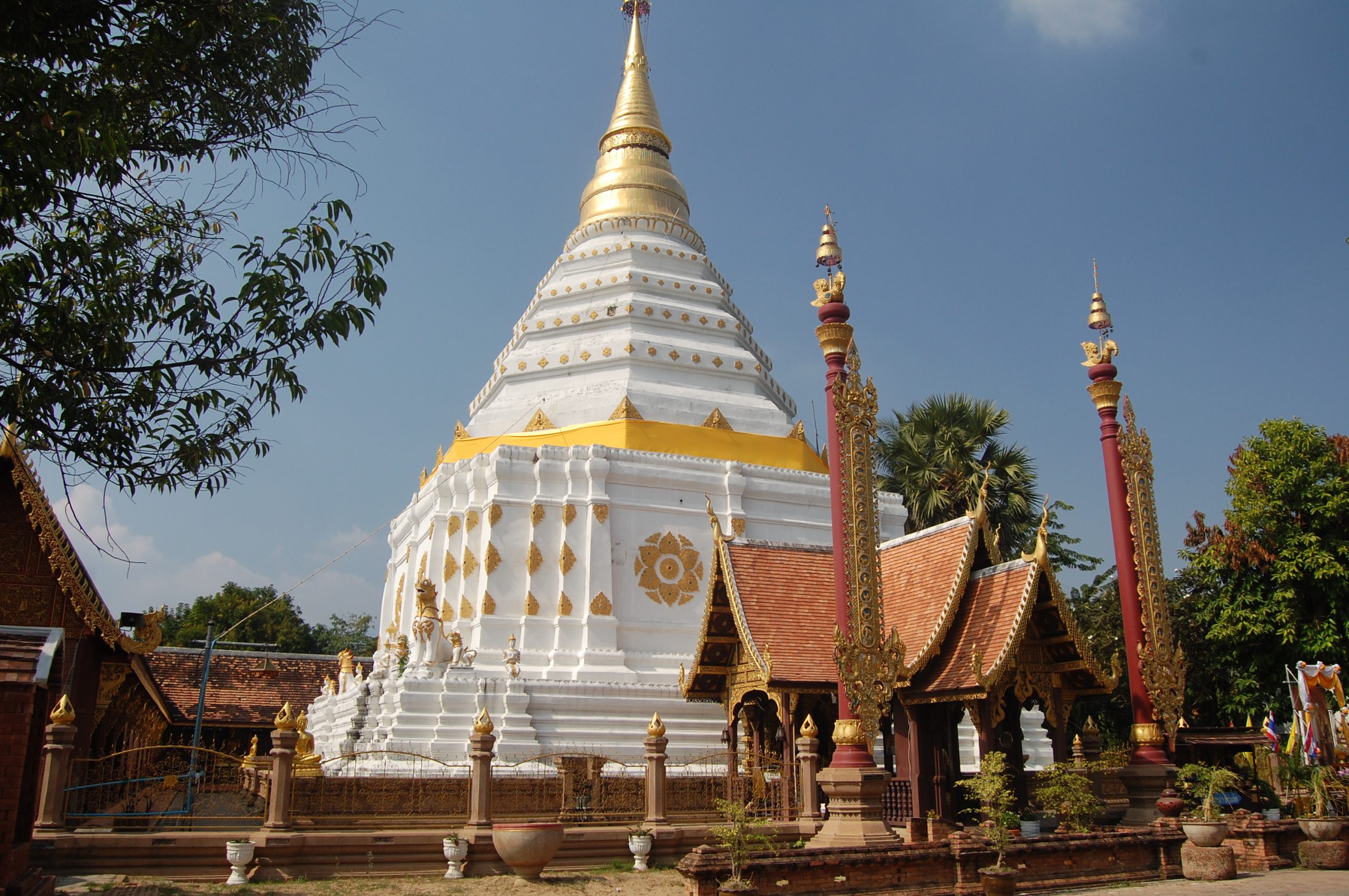
Chiang Mai Walking Tour Photo-essay
Chiang Mai Walking Tour Photo-essay I did a Chiang Mai Walking Tour Photo-essay for an online magazine about 7 years ago. The photographs were taken in December 2010. I spent about a month in Thailand with 2 friends joining me for the second week and another friend joining me the last week. The third week I went to Chiang Mai in the northern highlands of Thailand. Bangkok to Chiang Mai is about 450 miles by road. A bus will get you there in about 10 hours depending on the time of day it could be 12 hours. Your bus fare would range from $15 to $30 depending on the class of service of the bus. Airlines will get you between cities in a little over an hour at $50 to $75. Getting There Many visitors believe that the only way you should travel to Chiang Mai is by train. It takes longer than the bus, 12 to 13 hours. It can cost more than the bus, but it is an experience. This might take a little planning, but you can get an overnight air-conditioned sleeper car for $30. Trains often sell out, but if you make a reservation the week before, you will likely get what you want. My trip had me on train 13 leaving the Hua Lamphong train station in Bangkok at 7:30 pm. There is an MRT station there as well. So getting to the train station is straightforward. The train arrives in Chiang Mai at 8:40 am. Shortly after the train departed, the staff came through will menus for meals and snacks. Placing an order they served it shortly thereafter. A table could fold up between you and the seat across. While there is seating for two on each side, only one seat is occupied on the sleeper trains. The set of lower seats fold down into a bed. While above, a Pullman-style bed pulls down. Not long after dinner was served, the train attendance moves through the car and converted the seats to beds. I had an upper berth, which was very comfortable and had a small fan. In the morning they came back and converted the beds back to seats. There was also a dining car opened all night. The article below the divider is the text of a photo-essay. I have included most of the original photos, and I have added a few more. Start your Chiang Mai walking tour anywhere. Chiang Mai Walking Tour Chiang Mai in the northern part of Thailand is a city with a population of only 200,000 but is a metropolitan area of about a million. Sitting in the northern highlands it attracts millions of tourists each year both domestic and international. In many people’s minds, Thailand as a tourist destination has a stigma against it as it is widely known as a sex tourism destination. Chiang Mai has largely escaped that viewpoint offering a range of both natural and cultural attractions. The 700 year old “New” City In the northern Thai dialect, the name Chiang Mai means new city. It was given that name when the city was established in 1292, 200 years before Columbus set sail for the new world. The city was set up in a rectangular shape however it is often described as a square with each side being slightly over 1.5 kilometers in length. Roughly one mile on a side. The city was laid out on the compass points, was walled and outside the wall was a moat. Measuring the city at the moat is most likely the reason for the difference in shape and size reported. As the population grew development start first outside the east gate that leads to a nearby river. Being a highly religious time and a religious people there was a number of Buddhist temples that were developed at the same time as the city was built and expanded. Today there are over 300 temples in the city and about 30 within the one square mile walled city. Over the centuries much of the wall has been destroyed by the effects of war, negligence and the ravishes of time. Starting in the 1960s parts of the wall have been stabilized while other parts and features of the wall have been renovated using historical documents as a guide. Today’s visitors can walk outside the wall for a nice four-mile (6Km) walk enjoying both the ancient and modern aspects of the city. The East Wall of Central Chiang Mai The east gate named “Tha Phae” ( sometimes you will see it spelled as Tha pae both versions as one or two words) makes a great starting point for a walking tour around the old city perimeter. This is the gate that leads to the river and was where the original settlement first expanded. It was the main entrance for the common people to enter and leave the city. The gate and the wall area around it have been restored to the original condition, the work was done from historical documents including a rare photograph from 1899. The renovators deviated from the original plans slightly as the moat does not cover a portion close to the gate and a park is currently there used for different events. Heading north from the gate you shortly come to the start of the moat. No longer effective for defense the moat has become a greenway around the city. There are grass and gardens around the city centering on the moat. This feature has made the moat a popular area for locals to relax. As I started my wall around the moat, the stand of a vendor of fish food caught my eye. There is a photograph of it here showing his hand-lettered signs and photographs of tourists feeding the fish in the moat and the birds. There are sidewalks along both sides of the moat also which makes for a very pleasant walk. They say that a photograph is worth a thousand words, so instead of ten thousand words do describe the three-quarters of a mile to the north wall, I will let ten photographs do the talking. Getting Around Town Among the photographs are images of two of the most common methods of public transportation in the city, the Tuk Tuk and the Songthaews. The tuk tuk is a three-wheel device that will get you anywhere you want to go. Like New York City cab drivers, Tuk tuk drivers have a bad reputation, some of it highly deserved. Always agree on a price before entering a Tuk tuk and insure if it is per person or per trip. Additional Tuk Tuk drivers have been known to guide tourists to establishments that charge very high fees and will use violence to ensure payment. The Songthaews ply routes around the city, simply flag one down and tell the driver your destination, he will let you know if it is on his route. Pay the driver at the end of your trip. The word Songthaews means two benches, which describes the seating in these pickup truck-style vehicles. The North Wall The north wall is the “head” of the city and originally the north gate was used only by the royals. The area around the north wall today is an interesting mixture of modern commercial buildings, residential areas, and historical temples. Unlike temples and churches of other religions most Buddhist temples are compounds with many building and residents for the monks and in some cases the nuns. In the late 1800 a group of Buddhists from the state of Shan founded a monastery in a grove of Pao trees outside the city. The monastery became known as the temple in the Pao grove or Wat Pa Pao. In 1891, the king and one of his consorts who were from Shan built the main buildings. You may visit this and any of the other temples just remember to wear appropriate clothing and shoes must be removed before entering a temple. Wat Chiang Yuen is another impressive temple across the moat from the north wall. It is not clear how old the temple is as it seems to predate the new city. Wat Lok Molee is the next major temple we come to as we continue west along the north wall. The age of the temple is unknown but the name appears in records from 1367. The Chedi was built in 1527. Chedi is also known as Stupa are dome shape buildings of a semi hemisphere shape and are meant to house the temple’s most significant relics. The West Wall The west wall does not have the historical significant as the two walls we have already passed. The major exception is the northwest corner also called the Hua Lin corner. Hua for head and Lin for aqueduct gives the corner its name as this is the point where an aqueduct entered the city bringing in fresh water. The current corner was renovated in 1800. Near this corner along the west wall is another section of the original wall as it was restored at that time. The South Wall The southwest corner is basically gone with just a small building which may have been a guard post remaining. Small sections of the wall exist, but the corner now is a park, with a small lake and space to relax, you can rent or buy bamboo mats and lay in the grass and enjoy the day. The south wall had one major difference from the others in that there were two gates into the city, and represents the feet of the city. Records indicate that the area south was mostly farmland. The East Wall Again As we come back to the east wall and head north back to the gate we see little of the wall and the area outside the moat is heavily commercialized. There is one temple of historical significance this time within the walled city and that is Wat Sai Moon. ( also known as Wat Saimoon Muang ). While the four mile walk around the old city could have taken from an hour or four depending on the time of each stop, you could spend days wandering inside the old city and still not see all the historical buildings and sights. Did you enjoyed this Chaing Mai walking tour? I took a few hundred photos the week I was there. I also took a cooking class. If you liked these photos of the Chaing Mai walking tour, You might want to check out my photo album on Flickr of the Nong Nooch Tropical Botanical Garden. The Nong Nooch Tropical Botanical Garden is a 500-acre botanical garden and tourist attraction outside of Pattaya Thailand
Philippine Eagle Foundation Davao
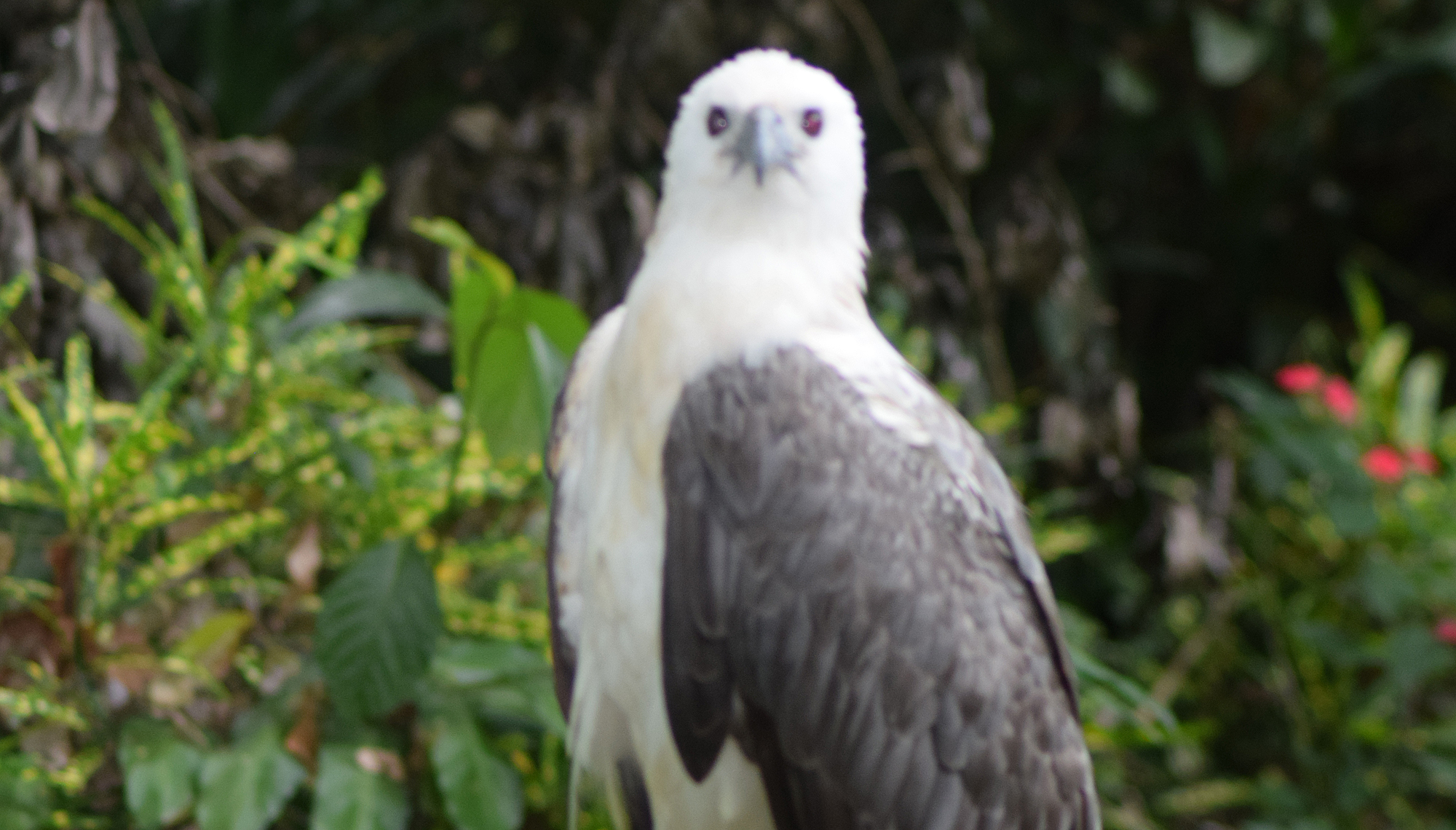
Philippine Eagle Foundation, Davao While in Davao, Philippines recently, I visited the Philippine Eagle Foundation’s conservation Center. It took an hour by Grab to get to the center, which is on the outskirts of Davao City. The Philippine Eagle, (Scientific Name: Pithecophaga jefferyi) also known as the monkey-eating eagle after its favorite food, has a Critically endangered Status. It is believed that there are less than 400 pairs remaining living in the wild. Eagles found injured are brought to the foundation with the goal of getting them well and returned to the wild. If they can not recover fully and are unable to hunt for themselves, they will stay at the conservation center. Birds at the center are also used in research and a breeding program. There are currently 7 Philippine Eagles in an exhibit for education, while the rest are isolated for conservation breeding and research purposes. The center is also home to other birds of prey who can not return to the wild. From their website: The Philippine Eagle Center (PEC) is an 8.4-hectare area located at the foothills of Mt. Apo in Malagos, Baguio District, Davao City, and situated within the Malagos Watershed. The Philippine Eagle Center primarily operates as a conservation breeding facility for the critically endangered Philippine Eagle (Pithecophaga jefferyi) and other birds of prey. The Center is divided into different functional areas, such as: Conservation Breeding Area. This is where the breeding birds are found. This area is restricted to the public and only the conservation breeding personnel are allowed on its premises. Food Stock Area. This is where the food for the raptors and other animals are raised to ensure a disease-free stock such as rabbits, white mice, quails, and guinea pigs. These stocks are needed for the daily food requirements of every animal at the Center. Exhibit Area. This area is open to the general public, wherein exhibit animals are displayed. It is further divided into two parts: The close canopy (covered by trees) area is a natural forest adjacent to the Malagos Watershed. Here you will find large old trees and the first few cages that the Philippine Eagle Foundation ever built. Being a natural forest, this part of the Center is relatively rough compared to the rest. The plaza/exhibit part is an open canopy area with concrete pathways leading to every enclosure, kiosks, and benches available for the guests. The conservation center is a little underwhelming. Overall, it is very small but depending on the amount of time you watch the birds and other wildlife can take you anywhere from 30 minutes to 2 hours to see. Three hours for photographers. There are a number of cages that each house one bird, mostly Eagles, the rest other birds of prey. An audio-video presentation is also available. There is an “island” of Long-tailed Macaque. I will admit it was amazing watching the social interactions these primates had between themselves. The foundation’s website also has this to say: We need to protect the Philippine Eagle for the following reasons: It is found nowhere else except in the Philippines, where it is the country’s national bird. Losing the species to extinction would also mean losing a nation’s precious biological heritage. It represents a rare product of evolutionary creation. Based on recent genetic studies, it has no close relatives left among the living species of eagles in the world. Losing them would mean an irreversible loss of a unique species. The Philippine Eagle is the top predator of the Philippine tropical rainforest. It plays an important role in keeping the ecosystem in balance and provides an umbrella of protection to all other life forms in its territory. The Philippine Eagle is embedded in the oral histories and other cultural artifacts of several indigenous groups in the country. This indicates that it performs a role in the human production of unique cultures. Economically, the presence of a healthy eagle population can also be a source of livelihood for the communities living near its area, such as eco-tourism. Additionally, a healthy forest helps control soil erosion, mitigate the effects of climate change, minimize flooding, and provide additional sources of food, medicine, clothing, and shelter for our people. This different spectrum of values unifies the diverse facets of our society. The role that the Philippine Eagle plays rightly deserves its title as the Philippine national bird- a symbol of unity, beauty, and hope. This underscores the need to protect it for future Filipinos and the rest of the world to benefit and enjoy. The entrance to the center is only 150 pesos for adults, less for children. That is about USD 3. We took a Grap (merged with uber last year) to the center from downtown to the center for about 700 pesos, $14. On our return trip, we took a trike to the transportation center nearby for less than a dollar and from the transportation center took a L300 (a commuter style van) back downtown for about $1 each. Overall, a very nice outing. #Wildlifeishere #CelebratingWildlife

Trotters Harness Racing Paris Style
Standardbred Racing with a Twist. The evening I spend watching the trotters race at the Vincennes Hippodrome in Paris was great. I mention some of the highlights of the track in the post VINCENNES HIPPODROME OF PARIS. The racing experience was different as well. Yes they were racing standardbreds, but there were many differences in how they raced. Here are some of my observations. Trotters In the United States there are more pacers than trotters. In Canada there seems to be more trotters but there is still a good number of pacers. In Europe, they have trotters. When I was living in Germany, I only saw trotters racing. In fact the name of the sport translates to trotting horses. The French counter part of the United States Trotting Association is LeTrot. The night I went to the races there were eight races. All of them trotters. Another difference was that two of the eight races were under saddle. While there are some races under saddle in the United States they are primarily demonstration races. The coloring is more varied in the European trotters. Breaking Rules. In the US, when a horse goes off stride (changing gaits) the rules require the driver to pull the horse to the outside and bring them back on gait. The horse must also not gain a distance advantage. If these actions happen, then the horse can rejoin the race. A prime example here is the November 25th race that my 1% horse Nower Power was in. Approaching the finish line in a clear second place, he broke stride. The driver tried to bring him back on stride and took him outside. He cross the finish line still off gait. However, as he did not gain a distance advantage, he was declared to finish second. In Europe, if a horse changes gaits, they are disqualified. There seem to be more horses going off stride but part of that is likely how they race. More later. Drivers and Jockeys In the US, we use drivers behind the horses and riders if mounted. In Europe, they are jockeys. Also in the US, drivers register their own colors to wear while racing. In Europe, the jockeys wear the colors of the owners. Distances Here is a surprising one for me. When we race in the US almost all of the races are at 1 mile, that is 1,600 meters. Some fair racing might be longer, but races where you bet are all 1 mile. Thoroughbreds race at different distances but not Standardbreds. My evening at the races in Paris saw the shortest race at 2,100 meters or about 1.3 miles. The longest race of the evening was 2,850 meters or about 1.75 miles. The Course. a look at the track An Aerial View of Vincennes Hippodrome. Image by Vincennes Hippodrome. In the US we have bank oval tracks. Generally you will find a race track has a track that is ½ mile, 5/8 mile or a mile long. Having each race at one mile the horse always start at the same position on a track. Vincennes Hippodrome is different. Not only do you have different starting points, you can have different tracks. If you look at the aerial photograph and the diagram you can see how the track is laid out. The day I attended they only used the smaller track PP. These videos will help understand the course. Take a look from ground level. Here is the 2100 meter Grand course The Start In the US and Canada, we have a starting car that the horses start behind. Europe sometimes uses a starting car. Of the 8 races I watched, 1 used a starting car. The rest are too hard to explain, you have to see to believe. Here is a start under saddle, later is a full race video with a sulky. The Entries Horseman often complain getting stuck in the 8th or 9th post position. The night I was visiting a couple of races at 10 horses, two had 12 horses, but 15 and 16 horses were the most common. 22 November 2017.J-68 NIGHT LAUNCHES GRAND PRIX D’AMÉRIQUE EPIQE SERIES FINAL COUNTDOWN The Prix d’Amérique is the final of a series of races at the Vincennes Hippodrome. Created in 1920 as a tribute to the United States’ commitment to World War 1, the Grand Prix d’Amérique is the planet’s biggest trotting race. The star harness event brings together the World’s best performers over the classic distance of 2,700 meters. (about 1.7 miles) This series and the final race is the most prestigious in Europe. It is also considered the world championship. The Prix d’Amérique is raced in January each year with over 40,000 in attendance. It is broadcast live to 35 nations. The betting handle for the race is over 40 million euro and over 9 million betting slips are printed. The purse is a cool Million Euro (1.2 Million USD). I was at the race in 1996, and watched David Wade from Rosecroft race SJ Photo. Putting it All Together Take a look at this video of the Prix d’Amérique 2017 to see how races are done Paris style.

Churches of Pampanga Philippines
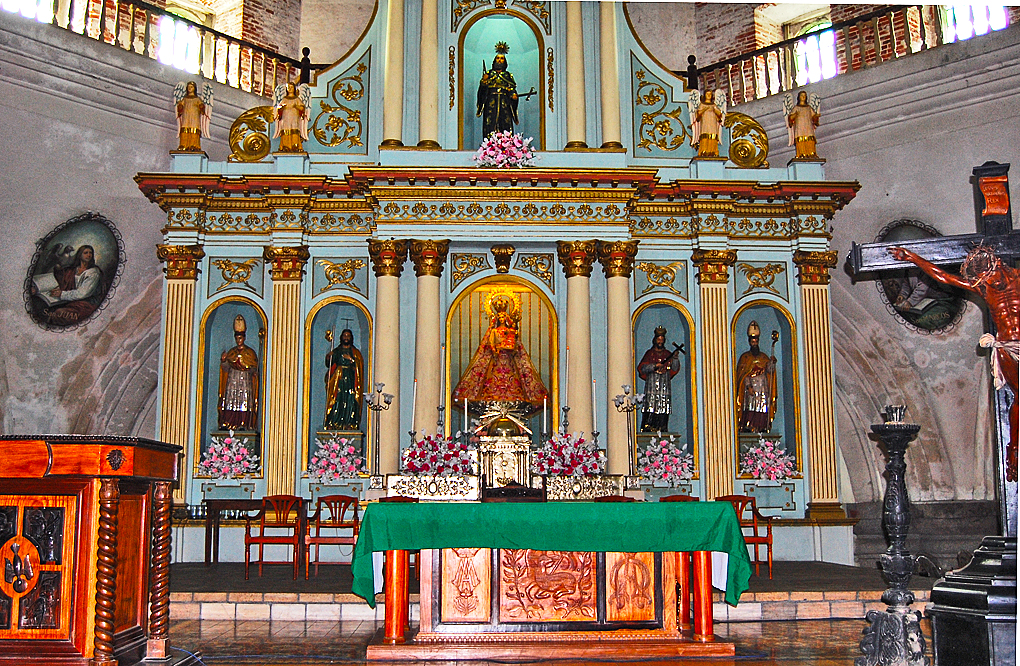
Churches of Pampanga Philippines From the late 1500’s to 1898, the Philippines were a colony of Spain. The Spanish’s mandate from the Pope was to find new lands and convert the heathens to Christianity. At the time, the Lubao River and what is now called the Betis River were navigable and it became a natural place for the Spanish to develop. The Spanish settle at a small native village and in 1576 established the Pueblo of Bacolor. The local “land lord” was Don Guillermo Manabat. San Guillermo Parish Church Spanish towns were built with a common concept. There was a plaza, often with a fountain in the center, on one side of the plaza was the church. The clergy selected Saint William the Hermit as the town’s patron saint. Saint William’s Spanish name was San Guillermo Emitano and the church became know as San Guillermo Parish Church. Today Bacolor is a small town shadowed by its larger neighbors San Fernando and Lubao. It has a very important past however. In 1745, Bacolor was the acting capital of Pampanga which at that time cover an area now divided into 6 provinces ( States ) In 1755 it became the official capital of the province. In 1762 when the British attacked Manila, the Spanish government moved the National government to Bacolor. In 1764, while still the national capital, the original church was replaced by a stone one that still exists. By Royal Degree Bacolor became Villa Bacolor, one of only three “Villa” in the country. The church that remains today has most of the features of the church built in 1764, however there has been significant changes due to the force of nature. In June of 1991, Mount Pinatubo volcano erupted with one of the strongest eruption in recorded history. The eruption change the course of history for many Filipinos and the effects of the eruption was felt worldwide as the ash cloud in the atmosphere eventual covered the entire earth and raised the worldwide temperature. Highly productive farmland was turned into waste land in the area around Bacolor. After the initial disaster, more follow in the form of lahar. Lahar is a combination of the ash that reached the ground, small debris and water, it looks like the concrete coming out a commercial cement truck. Thick,slow moving and unstoppable. Like concrete when it dries out it is super dense. Every heavy rain brought more material off the mountains. In September of 1995, the situation became so bad that half of the 12 meter high ( about 40 feet) church was under the lahar and the town of 50,000 had to be evacuated. In the photograph above, the green banners are above the top of the 12 meter high walls, as you can see today they are much less than 12 meters. In the photograph of the front of the church the entrance doors were at one time about 20 feet tall. If you look closely at the bell tower photograph, through the tree you will see an arch, it is just above ground level. That was the second level of the tower. The first level and the entrance are all now buried. As you walk around the outside of the church you will see small half circle windows, these are the top two or three feet of what once were large stain glass windows. Rounding the back of the church you come to a large open field, with a few triangular shapes sticking out and a small dome. This is the church’s cemetery used for about 250 years, there are thousands buried here. However the graves are all covered with about 12 feet of lahar. The roofs of the structures you see in the cemetery are two stories tall. There are plaques along the walls showing the names of those that are buried here according to the church records. Immaculate Conception Parish, Guagua Pampanga Within ten miles of San Guillermo Parish Church are another twenty or so churches built before the Spanish left in 1898. Each has its history, and some really stand out. Immaculate Conception Parish, in Guagua Pampanga is about four miles away. While much of the outside of the building is hidden from view, inside some of the original portions of the building can still be seen, while most of it is from it renovation in 1892. Church of Lubao Here is something for you to think about as you eat your eggs for breakfast. The Church of Lubao was built in 1630. the tower is part of the original structure. It is made from bricks. Like any masonry work, mortar is used between layers to stick them together. In this case the mortar was made of sand fixed with egg whites. In addition to the religious history of this church, the church was used as a revolutionary headquarters in the uprising against the Spanish in 1898 and in 1899 was used by the Americans as a hospital. St James Church St James the Apostle Church often called the Betis church is in the Betis section of Guagua Pampanga has been called the Sistine Chapel of Asia. The ceiling of the church has a number of finely painted panels with various scenes. It is a Baroque inspired design that was built initially in 1660 with wood and other lightweight material, however that structure was upgrade as it caught fire a number of times, in 1770’s the church was rebuilt with concrete materials. Betis Pampanga is a little town with an international reputation, a reputation for fine furniture. The local artisans produce some of the best hand carve furniture in the world. There are many myths and stories about when this started, most people discount the stories saying it is a recent development but archive documents suggest differently. Betis is the name of a wide river in Spain. When early Spanish settles arrived in the area they saw a similar looking river and named it Betis and the town took the name. In the Spanish archives there are many references to Betis carvings, however they had been attributed to the area in Spain. However documents found in the archives in Manila from the Spanish colonial period seem to indicate that the Betis was the one in the Philippines. The most accepted fairy tale is that in the late 1600’s the local workers learned wood carving from Chinese Slave labors who were task to build the interiors of the newly constructed churches. The Filipinos quickly learned and adapted the traits, they also became very skill at being able to reproduce items of arts from drawings and painting of the items. Being highly skilled wood carvers and devote ( whether voluntary of not) Catholics they spent considerable time creating beautiful alters and Retablos. The Betis church has eight chapels within a few minutes walk from the church. Each of these also have very elaborate Retablos. They are consider the finest collection of Spanish Retablos from their era. Smaller wood carvings like this one that is on the wall at St. James’s were a status symbol in the late 1700’s and early 1800’s. The Spanish controlled the wealth and very few Filipinos were allowed to have the finery that the Spanish enjoyed. The locals used the carvings as their show of devotion and if it was expensive and everyone knew it, well that was secondary. The Spanish left their influence on the Philippines in many ways, but most of those ways center around the church. Churches such as these with long rich histories are a product of that time. Note: This article was written about 3 years ago for another website. However, I had retained all rights. That website is no loner active, so I uploaded the articles here. It was one of 6 photo essays that I did for the other site.
 Hometown Travel Photo-essays
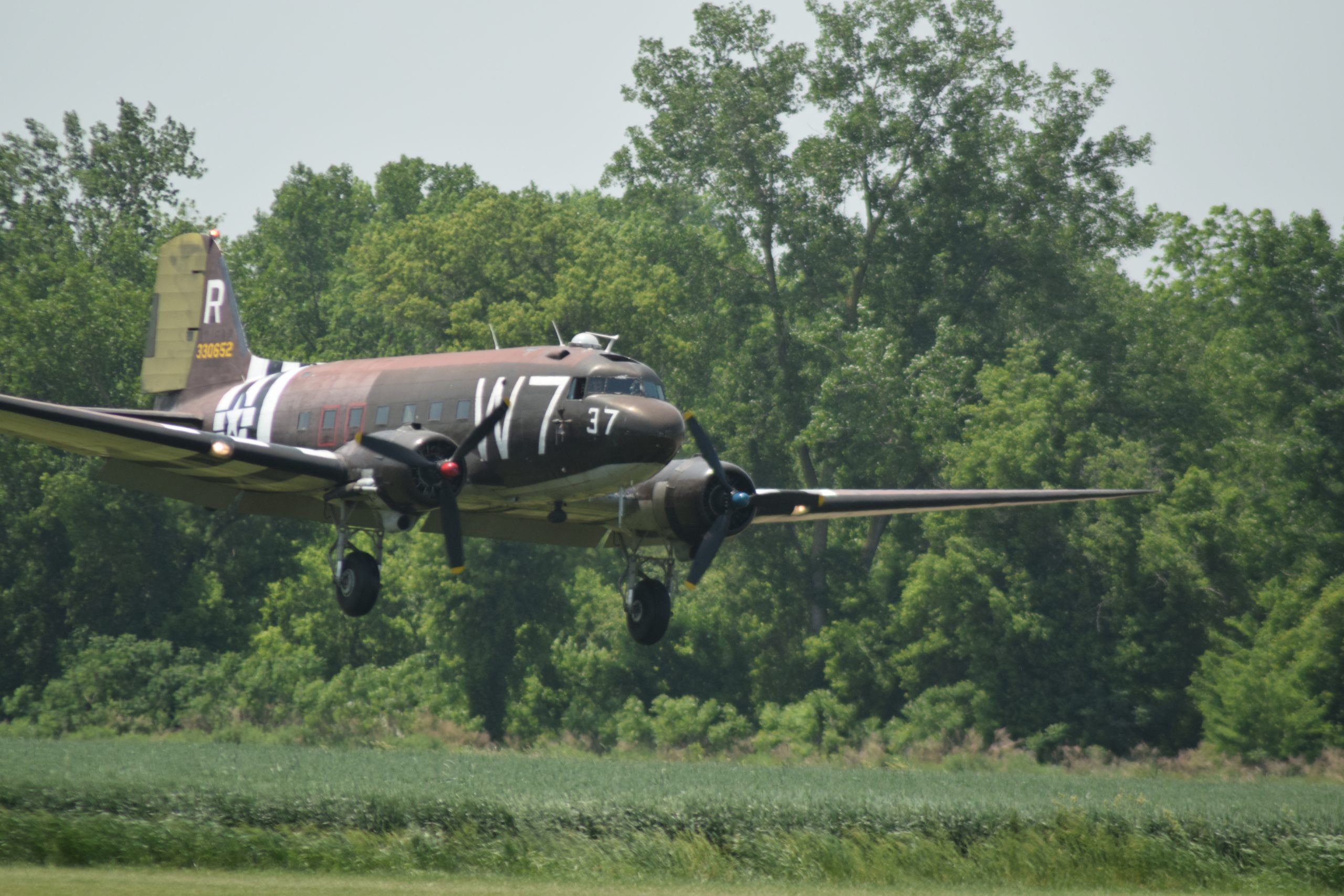
National Warplane Museum Airshow
The Seneca Indians called the valley jo-nis-hi-yuh meaning beautiful valley, and it was the name of a small Native American settlement. Over time the name evolved to Genesse and was applied to the river running through the valley. In 1790, two brothers James and William Wadsworth, purchased land from the Seneca nation, and the village of Geneseo was established. A portion of the village has been designated a National Landmark. Today, the population is around 11,000. Geneseo is generally considered to be a college town, the home of SUNY -Geneseo which has about 5,000 students. Geneseo even has its own airport. Owned by the Wadsworth family, the airport has no commercial flights, a grass runway, and during the summer months is open daily from 10 am to 6 pm. The rest of the year, it is open 3 days a week. It is, however, the home of the National Warplane Museum. While the village of Geneseo does deserve its own photo essay, this one is about the National Warplane Museum and its annual airshow. National Warplane Museum Copied from Wikipedia: The National Warplane Museum is a warbird and military history museum currently located on the grounds of the Geneseo Airport in Geneseo, New York. Founded in 1994, the museum restores, flies, and displays vintage military aircraft from the Second World War and Korean War eras. In 1998, after a split developed in the membership with two-thirds of the group wanting to move to a modern airport and grow, the National Warplane Museum moved to the Elmira-Corning Regional Airport near Horseheads, New York. In 2010, the Horseheads museum reinvented itself as the Wings of Eagles Discovery Center. In 2013, the National Warplane Museum name was reacquired by the 1941 Historical Aircraft Group which remained in Geneseo. The museum hosts the annual Geneseo Airshow, billed as the “Greatest Show On Turf.” Aircraft collection: Douglas C-47 “W7” – Restored and airworthy Beechcraft C-45 – Restored and airworthy Douglas B-23 Dragon – Stored, awaiting restoration Fairchild C-119 Flying Boxcar – Undergoing restoration Fokker DVII – (Replica) airworthy Antonov An-2 “Natasha” – Undergoing maintenance, on display Lockheed T-33 Shooting Star – On display North American AT-6 – Undergoing restoration Grumman F6F Hellcat (Replica) – On display Beechcraft UC-43 Staggerwing – Airworthy Aeronca L-16 – Airworthy Piper L-21 (Replica) – Airworthy YO-55 Ercoupe – Airworthy Ryan Navion – Airworthy Aero Commander 100 – Airworthy Lockheed C-130 Hercules “Saigon Lady” – Undergoing restoration National Warplane Museum Airshow I saw a news article about the then-upcoming airshow in an online article. I went two years ago and was a little disappointed, however, in fairness it was while things were just coming out of COVID lockdowns. I decided to grab my camera and head out there for a photo excursion and to enjoy the aircraft. The village and college is built on a slope and in the valley floor is the airport. As I drove down towards the airport, I was surprised by the number of cars that were parked there. I should have done a little more research before I arrived, as they had a “tailgate” entrance fee. The general admission fee is $35 per person, which was a bit high I had thought. However, after seeing some of the flights and walking around. I felt it was worth it. You could bring your own chairs or blankets and sit in a section for GA to watch the show. I did notice one section on the showline where no one was sitting, however, there were many photographers. I will apologize now for the quality of some of my photos. I did use my zoom lens for some of the photographs. However, it is a manual focus, and it was hard to keep some planes in focus. Also, it is time for me to get a new lens as the zooming collard is not reacting right. There are two other options. One is a reserve seat, that includes a chair in a covered area by the showline. They also have their own bathrooms. The other option is the “tail gate”. The fee depends on the location and ranges from $100 to $150. There are three zones and within each zone spaces are marked off. Each space allows room for your vehicle and chairs or blankets. The fee also includes admission for as many guests as your vehicle can legally hold. Enjoy the Planes Too Much Wind I arrived a little later than I had planned to, so I did not see all the flights. When I did arrive, they were talking over the loudspeakers about W7 and its mission on D-Day 79 years ago (a day short). One of the items mentioned was the accuracy of the pilot of W7 that day and the expertise of the paratroopers. The pilot placed them exactly on target for their release and the paratroopers landed all within close proximity of where they should have been. They were credited with the most accurate jump of the operation. One of the men in that conversation was from an organization named ROUND CANOPY PARACHUTING TEAM – USA. They do parachute jumps WWII style. They use parachutes of the same design as those used by the paratroops that jumped into D-Day. They had a team loaded into W7 and they were aloft waiting for a go for jump. However, at the time there were wind gusts that prevented them from jumping. The team also has some members in Europe who will be jumping in D-Day celebrations on the 79th anniversary. That would have been very interesting. Vietnam War There was a small section with Vietnam and WWII reenactment. The Vietnam era was around, a couple of Vietnam-era planes and had a range of military items from the time. Most I recognized and even used. The first thing that got my attention was the tents that were also ponchos, or where they ponchos that were also tents. The top photo shows a Mermite container in the background. They were used to bring food to field sites. They did work really well all things considered. They could keep a hot meal hot or cold meal cold for hours. The mess kit was your plate. They also had a few C-Rations. The ones from around Vietnam were basically the same as soldiers in WWII ate. Many would say we ate rations made for WWII. The MRE– Meal Ready to Eat — replaced the C-ration, it was an improvement. Later MREs were better and in fact even edible. The Saigon lady has an interesting history. As Saigon was falling to the Viet Cong, a pilot “borrowed” the C-130 to fly his family and others out of the country. It was possibly the last plane to escape. The Museum’s webpage has the story. While not my favorite military aircraft, I have more time aboard C-130s than any other aircraft
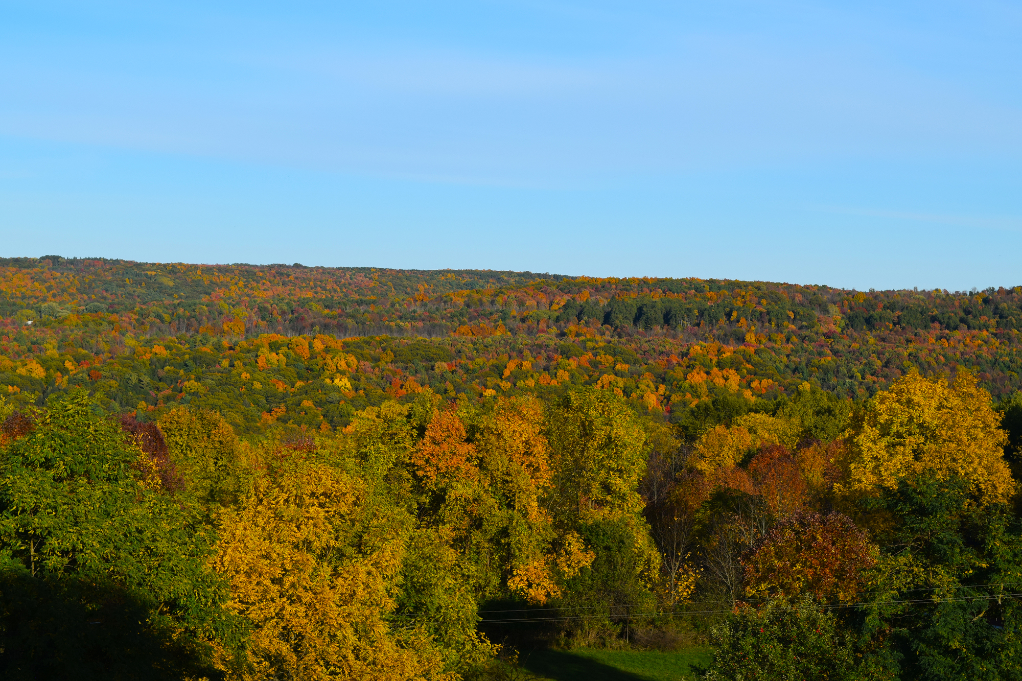
Fall Foliage of Hemlock and Conesus Lakes
Fall Foliage The fall foliage this year has been magnificent. This being my first year living in the Finger Lakes Region, I can not say if this was an average year or not. Everyone gives top credits to the New England area for fall foliage, but I sure the Finger lakes can beat them out. Bristol Mountain Ski Resort opens up a chair lift each fall and thousands of people use it to explore the fall foliage from the ride up and from the peaks. I thought about doing it, but, figured it is a waste of money. The view from my window at St Micheal’s is a mountain top view. I saw my first glimpse of the leaves at the beginning of September when I was up at the Thousand Islands. Two weeks later, you could see the leaves changing here in the Finger Lakes. My walks in the woods or along the lakeshore revealed an ever-changing palette of colors. Starting from the north boat launch parking lot, this trail heads south on a wide path for about 1.75 miles. There it continues on a narrow path reaching the south boat launch parking lot a number of miles away. Hemlock Lake is a part of the Hemlock-Canadice State forest. Unlike the majority of the other Finger Lakes, there is no development around the lake. Conesus Lake St Michael’s Mission, where I live, is on the slope above Hemlock Lake. However, it is in the town of Conesus. Conesus Lake is about 4 miles to the west. The difference between the two lakes is hard to comprehend being so close. Conesus Lake has a shoreline that is built up. There are houses along most of the shoreline and in many places, they are just a few feet separating homes. While Hemlock Lake is restricted to human-powered boats and boats 17 feet in length and any motors 10 HP or less, Conesus is not. A nice summer day will see hundreds of boats on Conesus Lake. Conesus State Park is about 4 miles from the north end of Conesus Lake. The park is really just a boat launch site and a large parking lot. Kayaks can launch here as well, however, there are four hand launch sites around the like that will be a better choice. Letchworth State Park Do not have time to take a trip to the Grand Canyon? Then visit the Grand Canyon of the East, Letchworth State Park. Voted the best state park in the United States and the best attraction in New York, it is a great place to visit any time of the year. However, it really is at its best in the fall. From the state’s website— The Genesee River roars through the gorge over three major waterfalls between cliffs–as high as 600 feet in some places–surrounded by lush forests. Hikers can choose among 66 miles of hiking trails. Trails are also available for horseback riding, biking, snowmobiling, and cross-country skiing. Before you go, it is best to go to the state website and download a park map. Putting Letchworth into your maps program and having it give you directions is not the best choice. The park straddles the Genesee River. The park is 17 miles (ca. 27 km) long, in that distance, there are only two bridges. One is a railroad bridge near the south end of the park. The other is a footbridge near the lower falls. The GPS might place you 20 miles from where you want to be. You can see other photos I have taken of Letchworth State Park t other times of the year at my Flicr Letchworth album Last week the temperature was a nice 86° then, 36 hours later it was 34°. Since then, it has been mostly misty and no sun. I guess fall is about over and winter will be here soon. Thinking of going cross-country skiing this year instead of hiking.
Wellesley Island State Park Camping
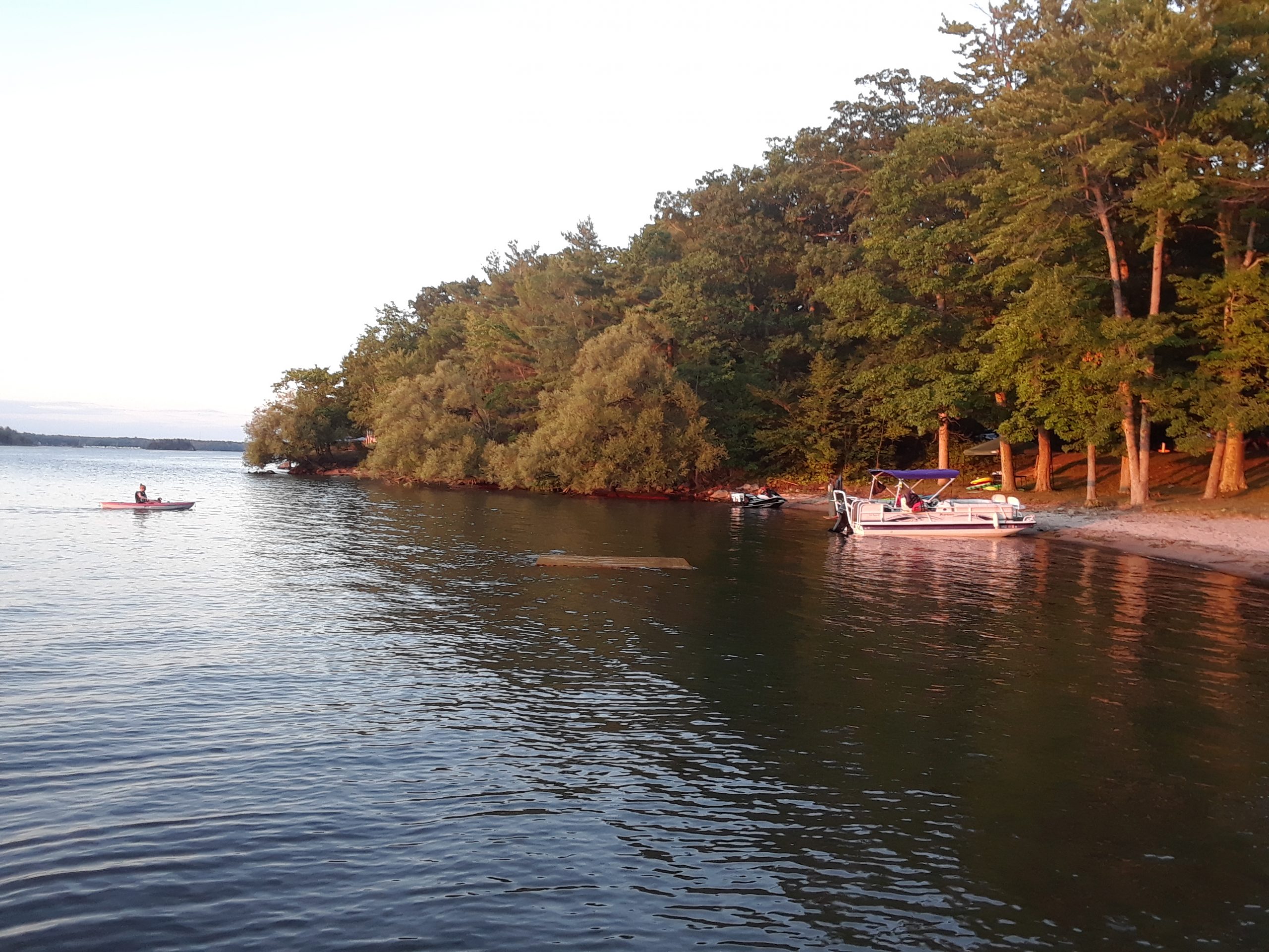
Wellesley Island State Park Camping I stepped out of my tent into the early morning light and looked out over the smooth waters of the St Lawrence River. A few birds are in sight, and they sometimes dive to the river to grab something that only they can see. Off in the distance is a large bird, I think it may be an eagle, but it too far away, and I am not an expert to be sure. Still, it is hypnotizing to watch. A few ducks complete the river scene. I am a night owl normally, but I will admit there is something special getting up early when you are camping. Welcome to Wellesley Island State Park. My first camping trip to Wellesley Island State Park was a last minute decision. A planned trip to Assateague Island, near Ocean City, had to be canceled because of travel restrictions. My first planned trip had also been canceled. I had been looking forward to my combined camping/kayaking trip. My brother has been going to the Thousand Islands for years to camp, boat and fish. Wellesley Island State Park is his preferred destination. He gets a campsite and a slip at the marina for his boat. Wellesley Island State Park is the largest camping complex in the Thousand Islands region with 432 campsites. I started looking for a week of camping but everything was reserved. Reducing my nights to a mid-week trip, I lucked out and found a few open sites. Even more so, I found a tent only site that was waterfront. I really enjoyed getting out for a few days hiking, kayaking and just disconnecting. There are campsites on either side, however, the sites are large enough that you have sufficient space. Let’s Do That Again When I got home, feeling the trip was too short, I looked for another getaway. I found a number of tent sites available the last week the campsites were open. The site I selected after much consideration was next to the boat launch in the “A” loop. It turned out to also be an excellent choice. Site A-22 was an outstanding choice for me. It was just a few feet from the boat launch. I inflated my kayak and carried it to the water to enjoy kayaking in the St. Lawrence. It also was only a three-minute walk to the restrooms and showers. Each of the sites, have a fire ring and a picnic table. Hiking The primary reasons for visiting the park is camping and boating. However, there is much here for the nature lover and hiker as well. The Minna Anthony Common Nature Center sits on a pristine 600 acre peninsula of Wellesley Island. The center itself has breathtaking views of Ell Bay and has a dock for visiting boaters. Ell Bay is very calm. There are 8 miles of hiking trails, make sure you bring extra water. My first hike, I had planned to walk just half hour. The trail was so inviting and offered many photo opportunities, I ended being out there for a few hours. Kayaking the St Lawrence River The ocean going ships do not ply the area where Wellesley Island Park is. There are, however, many pleasure boats and jet skies in the river. I am still learning to kayak, and more concerning, I am still getting used to the different way my Sea Eagle handles. So my first visit I launched from the Ell Bay side. It was a highly enjoyable experience. The only thing that stressed me was four huge turkey vultures. They kept stating at me like they were hungry, and I was dinner. I kept thinking of a cartoon I saw years ago with two vultures. One said to the other, Hell with waiting, I am going to kill something. I was able to paddle close to them, got to within five feet of one before it flew away. The wingspan was at least five feet, and I could feel the wind from the wings as it passed by. The park was less used during my second trip with fewer jet skies. My kayaking was from the A loop launch. I could just grab my kayak, and hit the water. I even paddled all the way to Canada. Okay, it was only a quarter of a mile, but it was an international trip. The Island Wellesley Island is one of the largest islands located in the St Lawrence River’s Thousand Islands Region. The Thousand Island Bridge connecting the United States and Canada is really five bridges. Three of the bridges are in Canada, one in the US and one is the border crossing. The bridge on the south side of Wellesley island connects to the US Mainland while the bridge to the north is the border crossing. Most of the island is lightly inhabited, being mostly marsh land and state parks. Other state parks nearby are Canoe-Picnic Point State Park, Grass Point State Park, Dewolf Point State Park, Waterson Point State Park, and Wellesley Island State Park Golf Course.
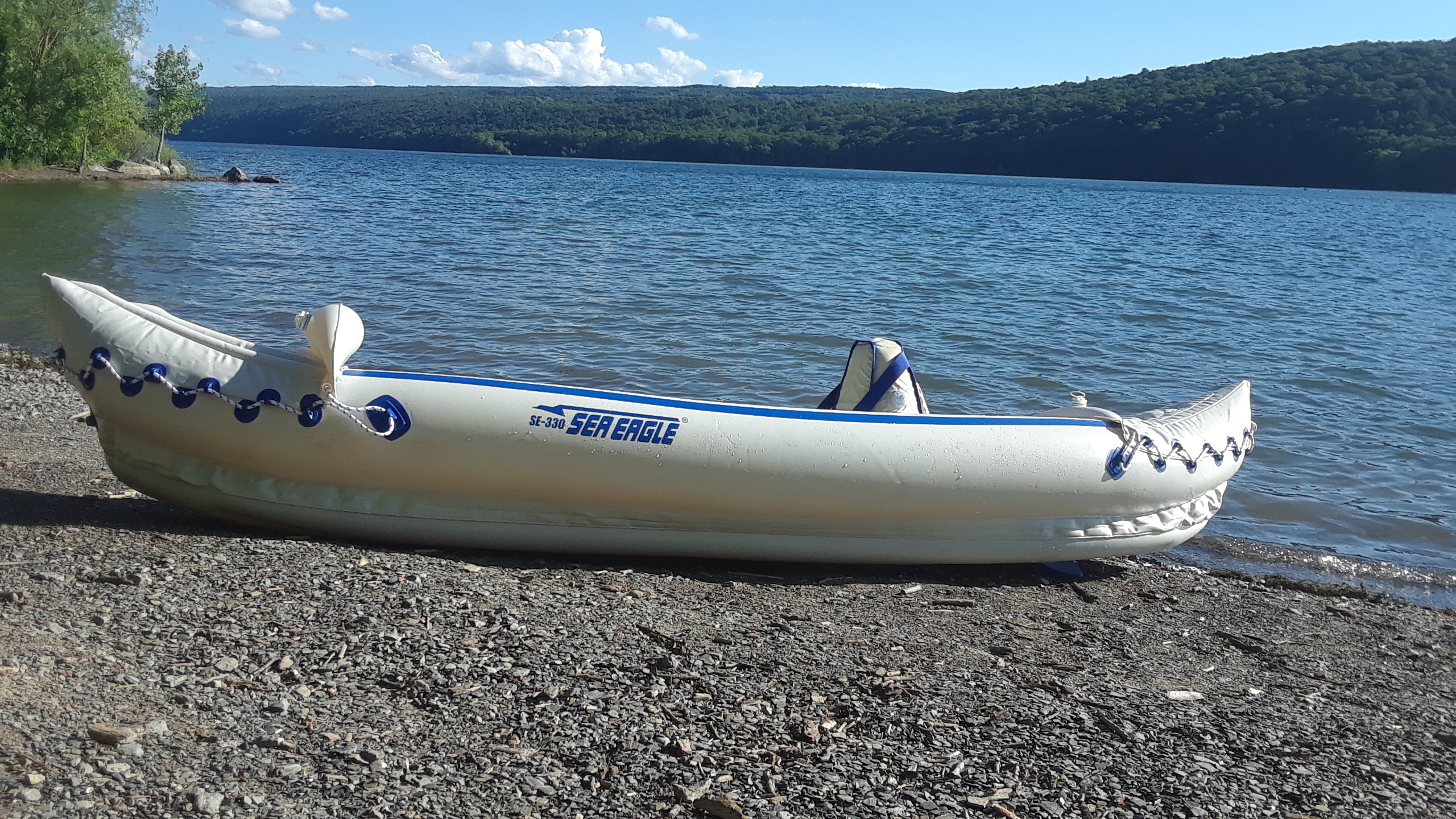
Kayaking with My Sea Eagle 330
Why A Sea Eagle 330 This is going to be a combination post and product review of my Sea Eagle 330. I am fairly new to kayaking. Over the last few years I started renting them and going to different places around the area. I enjoyed it and was at the point where I could justify buying one vs renting them. However, The cost of a roof rack was almost $500 for my car. I could have just gotten the cheap pads and tie down kits but felt I could not trust them for anything but a short drive. So getting my own kayak was set aside for a while. While cleaning out my mom’s garage, a large canvas bag was found and since no one knew what it was, it was sent to the dumpster. Later, I pulled it out to be examined later. A Few weeks later, I was online looking for a cheaper roof rack. A link for sea eagle popped up and I saw it was the same bag that I had rescued earlier. I went to the garage and with my brother emptied the bag. I found inside a Sea Eagle 330. We put it back in the bag and it went to my storage space to wait for more time and warmer weather. When I did have time, I found it was very dirty and missing the paddles. Before rushing out and buying a new paddle, I inflated it and let it sit for a weekend. When I returned, I found that two of the chambers were mostly deflated. When I had inflated the kayak, I liked it. It looked good and I had no problems bringing it to storage, nor inflating it with the foot pump. I was not looking forward to looking for a leak, plus I was not sure how long it had been in the garage. I knew it had not been used for at least 4 years. The best option was to buy a new one. I looked at the different packages and got the starter package. It is not on Sea Eagle website right now but it is the same as the deluxe package except it does not have the carry bag. I had considered the Pro Solo package, with the deluxe seat and carry bag. Since I had a carry bag and a deluxe seat with the old kayak, I opted for the starter set that had two seats and an extra paddle, in case I wanted to tandem. First Impressions When I took the kayak out of the shipping box, my first impression was the material was a good quality. It reminded me of a zodiac inflatable. After checking everything and preparing the items for the first time, it took me about 10 minutes to actually inflate the Sea Eagle 330. I sat in it a few minutes, then broke it down and packed it away in the carry bag that I had. A few days later, I took it to Hemlock Lake for my first on water experience. I found a flat section of ground with some grass and laid out the kayak. Pumping it up and getting ready was easy. The pumping took me about 8 minutes. I used the SEC seat that came with it. A few comments that I read about the Sea Eagle 330 said it was unstable. My first impression was the same. However, once I had a foot of water below me and a few full strokes I felt it was stable. I think it was the skegs dragging. I did not feel comfortable with the seats. They just did not seem to support me well. On my third outing, I switched to the deluxe seat and fell they are right for me. Taking it down takes a while, if you are caring for it properly. It needs to be rinsed off then dried before folding. Invasive species are a problem in my area so this is an important step. Also, it will keep it new looking. Once it is cleaned and dried, it only takes three or four minutes to fold it and place it in the carry bag. The carry bag will also hold the paddles, foot pump and life jacket. Sea Eagle vs Hard Kayak I have a dozen outings this year in my inflatable about the same as I had for the previous three years combined in a hard shell kayak. The hard shells I used were sit-ins with a large cockpit opening and 12 foot long. If I were to rate them against each other on a ten point total scale, it would be a 7 for the Sea Eagle and 3 for hard shells. Here are some of my views: Transportation: This is all Sea Eagle. I have a small Nissan Versa Note which is a hatchback. The carry bag fits sideways very nicely, so there is no need to lower the back seats. It stays in the car, so I can just grab swim trunks and head out. As I mentioned before, This is an important point for me. Speed: Hard Kayak has the edge here. I am not very fast even in the hard kayaks. Still, it seems to take more effort to get speed out of the inflatable. I do find it difficult to keep up with others. You will find me kayaking to relax and to enjoy nature, so I really not need to go fast. I seldom do a point-to-point paddle and I mostly paddle alone, so not a major point for me. Stability: I mention this above but will expand a little here. Once you get some water under you, I feel the Sea Eagle is as stable. There been a few times when I needed to deal with a wake from a passing boat. I felt the Sea Eagle handled it better than when I did the same in a hard shell. Yaw: Yaw is the deviation from a straight course. I feel that there is more yaw in the inflatable. It is not so much that it is an issue. Wind has more influence on the inflatables then a hard shell. This noticeable to me when I am kayaking on Hemlock Lake which has some wind at times. Sea Eagle Kayak Tips: Here are a few tips: Seat position: Where you position the seat has some impact on your stability but more importantly your control. The instruction video and owners manual recommends that solo paddlers position the seat a little behind the middle. I am more comfortable moving it back a little farther. Also, once you have moved away a little from shore, balance yourself in the seat. Form: I found that I needed a higher stroke because of the higher sides. In the hard kayaks, I used a feathered paddle. I am more comfortable with my paddled unfeathered when I am kayaking in my Sea Eagle. Extras: I have a waterproof pouch with a neck string that holds my car keys and my cell phone if I take it along. I loop the string around the side strap of the deluxe seat and place the pouch portion in the pocket of the seat back. Waterproof Camera: I missed some great photos because there was no way I would take my cell phone out of the waterproof pouch, and I was not going to bring my digital SLR. I bough a point and shoot camera that is waterproof. The wrist cord attaches to the valve holder of the seat. Still experimenting on the placement, but I can reach down, release the camera and get some on water shoots. Inflation gauge: There is a clear flexible plastic gauge that you hold against the hull to measure that the hull is properly inflated. Note clear plastic translates to easy to lose. Buy a couple extra before you need them, only a few dollars each. Cleaning supplies: At the end of the day, I will take a wet towel to get any mud or marks off the kayak, then wipe it down with a dry towel. I also have a towel I can kneel on while I fold the kayak. As I fold the kayak, I might need to wipe it off and dry it. Some marks are stubborn, so I will unfold the kayak at home and clean it with a cleaner designed for marine vinyl. I plan on keeping my kayak for years but looking new. My waterways: Here is a brief rundown of where I have used my Sea Eagle. Hemlock Lake: This is one of the minor Finger Lakes of Upstate New York and is the closest to my home. It is also a water source for the city of Rochester. The shore line is undeveloped and is a state forest. Kayaks, canoes and small fishing boats (trolling motors only) are the only boats allowed in the lake. The lake is seven and a half miles long with two boat launches. The northernmost mile of the lake is closed to boating. Hemlock lake is in a valley of sorts with hills on the east and west shores. Conditions can get windy if you move away from the shore as hills can create a wind tunnel. There is less effect at the south end. The south boat launch is at a point where the areas south is more wetlands. The two portions of the lake give you different experiences. Hemlock has great fishing and some nesting eagles. Mendon Ponds Park: This is the largest park in Monroe County and has always been one of my favorite places to hike. Now it is also one of my favorite places to kayak. The Hundred Acre Pond is a great place to explore. The water is shallow and mostly flat. Like Hemlock, it is for Kayaks, canoes and small fishing boats with nothing larger than trolling motors. Great place only a few people on the water. The first time I went there, it had only 6 kayaks, all inflatables. Wellesley Island State Park: The park is located in the Thousand Islands region of New York in the middle of the Saint Lawrence River. The park has three boat launches with two being hand launches. The Ell bay side of the island has less boat traffic and is perfect for kayaking. I did get a little nervous when four turkey vultures kept an eye on me. Two of them had wingspans that must have been five feet. From the Sea Eagle Website About the Sea Eagle 330 Inflatable Kayak Our lightest, most portable kayak is America’s most popular, the versatile Sea Eagle 330. It weighs just 26 lbs. and packs down small enough to fit in the smallest car trunk. Don’t let the lightweight fool you, it’s a rugged kayak able to hold 2 people or 500 lbs and yet easy enough to be carried and paddled by one. Specifications Person Capacity 2 Hull Weight 26 lbs. Length 11 ft. 2 in. Width 2 ft. 10 in. Interior 9′ 6″ x 15″ Load Capacity 2 Person or 500 lbs. Deflated 24″ x 16″ x 7″ Chambers 3 (port, starboard, floor) Tube Diameter 10″ Air Valves 5 Deluxe One Way Inflation time 6 min Seam High Frequency Welded Material 33 mil Polykrylar (K80 PVC) Floor Inflatable I-beam construction Whitewater Rating Suitable up to Class III Inflation Pressure 1.1 psi I have really enjoyed my Sea Eagle 330, and for me it was the right kayak to buy.
Ocean City and Assateague Island
Ocean City and Assateague Island National Seashore The COVID-19 crisis has had a major impact on everyone’s life. At the beginning of the year, I had planned out my vacation and mini-vacation plans for the year. My plan included two trips to Assateague Island, near Ocean City. The first one was canceled when the National Park Service closed camping. The second trip I planned for next month. I hope the restrictions are released so that I can go. In May 2019, I went camping at the seashore and a side trip to nearby Ocean city Maryland. While it is late, I thought I would share some photos I took that trip. Ocean City I spent a few hours walking around Ocean City Maryland while I was there as well. The visit was the week before their spring festival which officially open the season for them. I had the boardwalk mostly to myself. Few shops were open still it was a nice afternoon. Assateague Island Assateague Island has both the National Seashore and a Maryland State Park. The National Seashore has two sections divided at the state line of Virginia and Maryland. A fence separates the two sections. An owner of a four-wheel drive vehicle can apply for an Over Sand Vehicle (OSV) use permit. This will allow them to drive on the beach past the public swimming and camping areas. However, normal cars can not use the OSV areas. The National Seashore has a number of beaches, nature trails and camping sites. There are seaside camping sites and bay-side sites. Most of the sites are drive in sites suitable for RV and tents. Restrooms and showers are nearby. For the adventurist there are back-country sites that requires campers to hike in or arrive by kayaks. These sites have no facilities nor water sources. While the primitive back-country sites does have a draw, that is not an adventure to do solo at least for me. I camped at one of the bay side camp sites in the B loop. Many of these sites are waterfront. Be careful of the horses, They are wild Both sections of the park have wild horses. The horses in Maryland belong to the NPS while the horse in Virginia belong to the Chincoteague volunteer fire department. Misty of Chincoteague a famous children book published in 1947 is about one of the horses of the Virginia herd. The horses in both herds are free to roam the island. While the horses appear tame and accepting of humans they really are not. Each year videos of interactions between annoying park guest and the horse appear online with the guest always getting the bad end of the situation. It you respect that they are wild, you can enjoy the horses. The campsite I had was just a short walk from the Life in the Marsh trail. Life in the Marsh Trail Hover over the image to see the tools to go to the second page. The numbers on the guide correspond to points along the trail. The Life on the Marsh Nature Trail is a bird watchers paradise. c Assateague Island and Life on the Dune One of the amazing things about Assateague Island is the variety of wildlife flora and fauna. There are three nature trails in the north section of the park, each a short distance apart. However, they represent completely different ecological zones. The Life on the Dune reminds you of a desert with shrubs and brush. My other post on the island had some photos of the dunes, here are a few more. Hover over the image to see the tools to go to the second page. The numbers on the guise correspond to points along the trail. If you have not already read it take a look at my earlier Assateague Island National Seashore post. Some great photos there too. You can more photos on my flickr page in the Assateague Island album
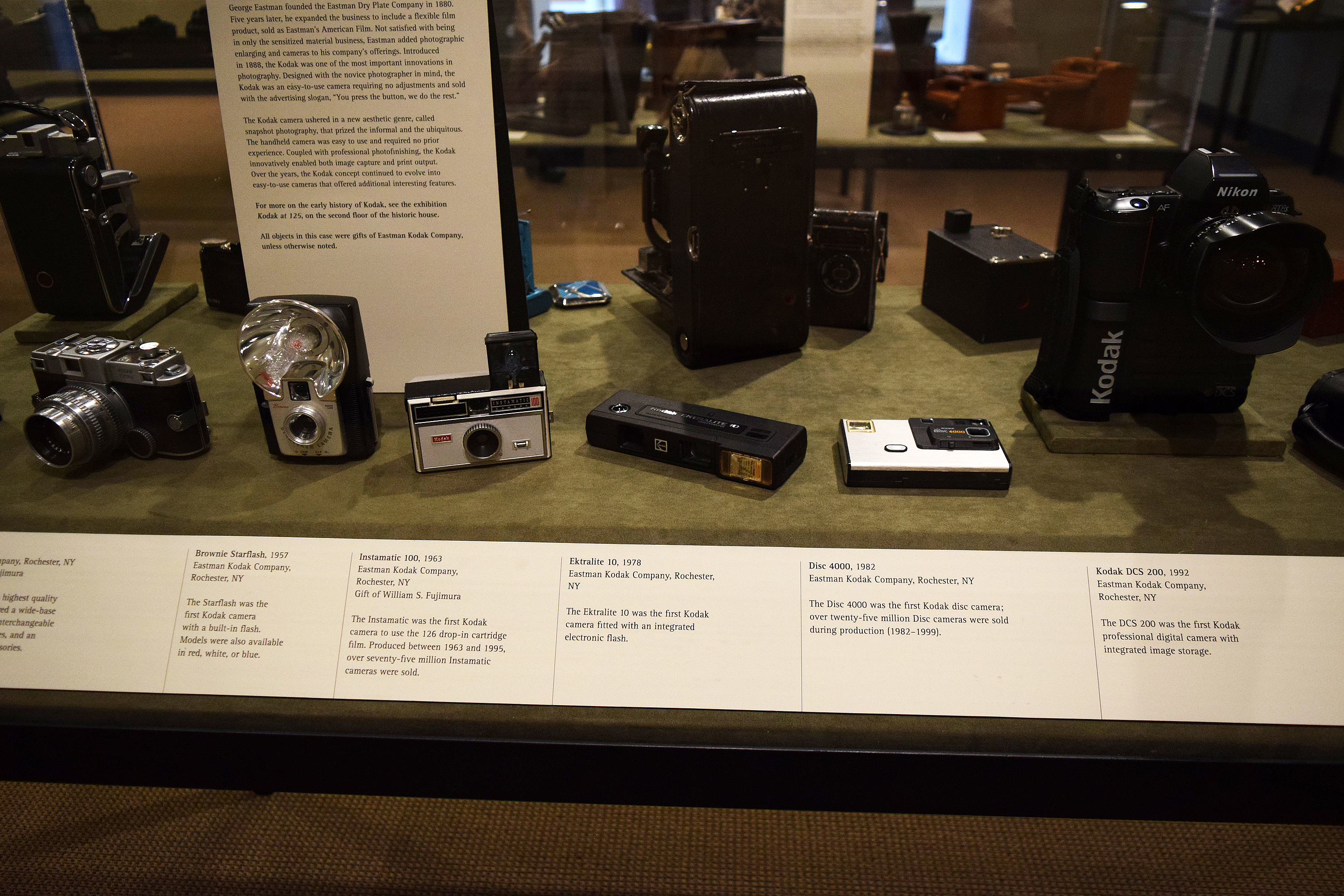
Eastman House and Museum
George Eastman was a very interesting man. His company Kodak created photography as we know it today. Before his inventions, Photography required huge pieces of equipment that were very expensive and required complex processing. His product could be hand carried, take multiple photos, then sent off to be processed and the camera reloaded. The Eastman House and the attached theater and museum is a must-do. Spring has not arrived, so the gardens are bare. I will visit again once the gardens are in bloom and will add to this article. For now, enjoy these images. The Museum The Eastman House The Cafe I plan on going back a number of times this year, and will add to this article as I do. for more information visit the Eastman House and Museum website. The George Eastman Museum is located in the East Avenue Historic Preservation District near downtown Rochester, New York. Many times we overlook what is in our backyard, so get out and do some Hometown Travel
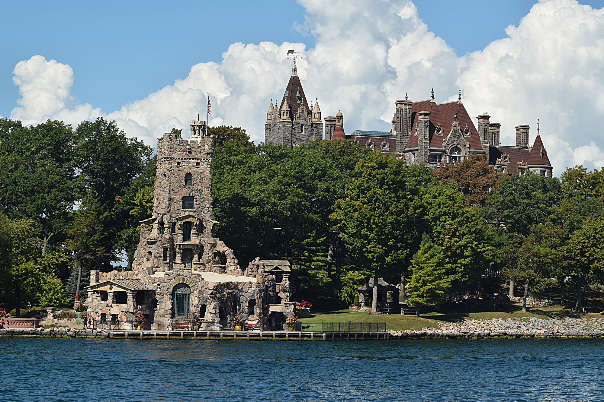
Thousand Islands
As Summer was winding down, I decided to take a trip to the Thousand Islands. The Thousand Islands has a rich history that helped shape both the United states and Canada. It was a factor in the War of 1812, was popular with Presidents in the late 1800s, and many millionaires built summer retreats here in the 1930s. The area is still a very popular summer getaway. Hover over the photo above to show the next arrow. Click on an image to go to the flicker album For those not in the know, The Thousand Islands is in the area where the Saint Lawrence River meets Lake Ontario. The Saint Lawrence River is the passage allowing the Great Lakes to empty into the Atlantic Ocean. The first fifty miles or so has many islands. While the area is known as the Thousand Islands, the official count is 1,864 islands. To be considered an island, the land must have at least one square meter of surface always above water. It also most have at least one tree and additional vegetation. The Saint Lawrence River also forms the border between the US and Canada. So some islands are in Canada and some in the United States. The border is not a straight line nor does it follow the center of the river. A treaty at the end of the War of 1812 divided the islands so that each country received the same land mass. However, Canada received more islands. The division impacted the border. The largest island is Wolfe. This island is about 29 kilometers (ca. 18 miles) long, with its width varying from around 9 kilometers (5.59 miles) to a few hundred meters at some points; its area is about 124 square kilometers (48 square miles). The smallest island is Tom Thumb. Just Enough Room Island /Mother-in-Law House Just Room Enough Island, also known as Hub Island is the smallest inhabited island in the world. The island is about the size of a tennis court. Purchased by the Sizeland family in the 1950s, the island has a house, a tree, shrubs, and a small beach. Local tour guides often misrepresent this house as being built by Bolt for his mother-in-law. Heart Island home of the Bolt Castle is the closest island to Just Room Enough Island. Heart Island and Bolt’s Castle Bolt Castle is a 120 room mansion that was never completed. There are many stories about it. I am going to borrow some text about it from wikipedia “George Boldt, general manager of the Waldorf-Astoria Hotel in New York City and manager of the Bellevue-Stratford Hotel in Philadelphia, and his family enjoyed an earlier frame cottage on Hart Island (the island’s original name) for several summers, which they greatly expanded. In 1900, George Boldt launched an ambitious construction campaign to build a huge masonry structure, one of the largest private homes in the United States. He engaged the architectural firm G. W. & W. D. Hewitt and hundreds of workers for a six-story “castle” as a present to his wife. In addition, four other masonry structures on the island are architecturally notable. Equally distinctive is a huge yacht house on neighboring Wellesley Island, where the Boldts had another summer home and a vast estate, incorporating farms, canals, a golf course, tennis courts, stables, and a polo field. The construction of Boldt Castle ceased abruptly in early 1904 after the death of Boldt’s wife, Louise Kehrer Boldt. Boldt never returned to Heart Island, leaving this structure as a monument of his love. For 73 years, the castle and other stone structures were left exposed to the harsh winter weather and occasional vandals. The Thousand Islands Bridge Authority acquired Heart Island and the nearby yacht house in 1977, for one dollar, under the agreement that all revenues obtained from the castle operation would be applied towards restoration, so that the island would be preserved for the enjoyment of future generations. In the two decades after acquiring the property, the Thousand Islands Bridge Authority spent some $15 million for restoration and improvements here, and work continues annually. The initial goal of the restoration of Heart Island was not to finish what had not been completed, but to restore the island to the state it was in when construction was halted.” The Shortest International Bridge Hoax I remember 30 years ago taking a boat tour of the Thousand Islands and the tour guide pointing out the “shortest International Bridge in the world”. On the tour I went on, they also pointed out the bridge and added a story about the owner having to pay taxes in two countries. However, maps from both the US and Canadian governments show that both islands belong to Canada. Still, it a nice story and great photo op. Boat Rides There are boat rides from both side of the border that will take you around the islands. Uncle Sam Tours from Alexander Bay is the one I used and highly rate it. The boat stops at Heart Island before returning to Alexander Bay. You can get off here and pay the entrance fee to visit the island and the castle. To return to the mainland you can take the next tour boat or a shuttle.